Current issues with the draft of the Comprehensive Plan
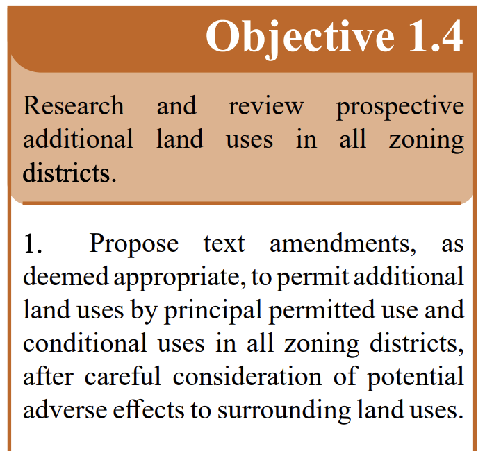
The issues Goal 1 Objective 4:
- Goal 1 Objective 4 undercuts zoning. The point of zoning is to limit the uses in each zone to those uses that align with that zone so that we may improve quality of life, protection and efficient use of resources, and protection of the environment. Zoning is not new in Jefferson County, nor are there suddenly new, previously uncontemplated land uses. Therefore, we do not need to be placing additional uses in one—or worse yet—all of the zones, especially not as principal permitted uses (by right). So why do we need to contemplate adding uses into zones that were previously not allowed? We don’t.
WV code 8A-7-8a requires that absent some large change to the character of a zone, to make an amendment to the text of the zoning ordinance the amendment needs to align with the Comprehensive Plan. With Goal 1 objective 4 as it is now written, a savvy entity could argue that the comprehensive plan now supports any land use being added to any or all zones as a principal permitted use (by right) as long as it has been “researched and reviewed”. In so doing this objective completely undermines zoning. If any and all uses can be in any and all zones, why have zones? If land owners cannot rely on the zones limiting development to zone appropriate uses, what is the use of zoning? - Goal 1 Objective 4 refers to all uses. In the previous draft Goal 1 Objective 4 referred to institutional uses, and Goal 1 Objective 5 referred to commercial uses. Now the combined Goal 1 Objective 4 refers simply to “land uses,” including all land uses (industrial, light industrial, commercial, residential, institutional…). This is far too broad.
- Goal 1 Objective 4 supports additional uses in all zones. The only uses that are appropriate and all zones are agriculture and conservation. Agriculture and conservation are already allowed in all zones. So, there are no additional uses that are appropriate to be considered in all zones. The previous comprehensive plan already supported commercial uses related to agriculture in the rural zone (baked goods, farm machinery repair, etc.). This could be carried over in this comprehensive plan instead of this very broad objective.
- Goal 1 Objective 4 fails to indicate what the outcome of the “research and review” should be for a use to be considered in new or additional zones. Is it currently reads the research and review does not need to find that the use is appropriate for or congruent with the new or additional zone. It is simply a check box exercise. Someone may argue that the comprehensive plan supports the addition of any use to any zone, regardless of the findings as long as a use has been researched and reviewed.
Other issues:
- In the narrative under Goal 1. It reads, “To ensure that any growth that occurs in Jefferson County is positive, the County must support land use regulations and policies that manage the types and locations of that growth. However, this should not infringe on the right of property owners to use and develop their land.” This second sentence negates the point of the first sentence and Goal 1 as a whole, by prioritizing development rights over other land rights.
- The importance of the Future Land Use Map has been down played by calling it a Future Land Use Guide. We are concerned that those wanting to change the zoning map in ways that do not align with the Future Land Use Guide will use this as a reason why this is ok.
Submit Public Comment
Use our portal to send to the Jefferson County Commissioners and staff. If you previously sent a letter through this portal, please resend with these updated comments.
Public Comment on Recommended Comprehensive Plan Draft for Jefferson County
Comments to consider for the Public Comment Period
There are several significant issues with the current comprehensive plan that undermine the protections that the comprehensive plan and zoning are intended to provide to property owners.
- Please remove Goal 1 Objective 4. This objective is so broad it would reduce the protections that zoning provides to property owners. If the Objective were sufficiently narrowed it would be redundant with the other objectives of Goal 1.
- Please remove the second sentence of the first paragraph on page 18. “However, this should not infringe on the right of property owners to use and develop their land.” This sentence prioritizes development rights over all other land rights, and thereby undermines Goal 1’s intent to balance the rights of all property owner.
- Please return the Future Land Use Guide to its previous name of Future Land Use Map. The new name of “Guide” down plays the importance of this element of the comprehensive plan. Those seeking a zoning map amendment may take advantage of this confusion. It should be returned to its original name.
Issues with Previous Drafts
The proposed action items in relation to the goals are found in the draft Comprehensive Plan. We have outlined the specific concerns for these items below. Just click on the arrow to expand the detail. The orientation of the images in each bracket is Goal, Objective, Action Item, Major Players, and Timeframe.
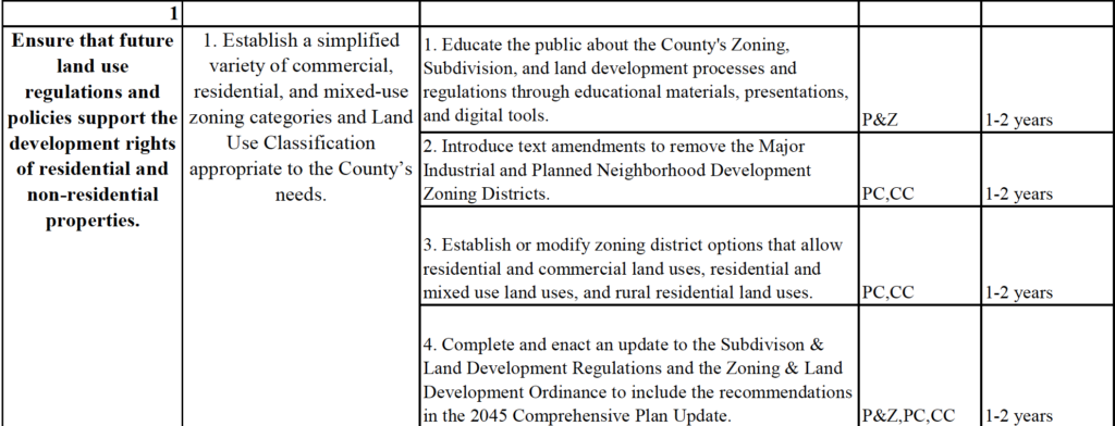
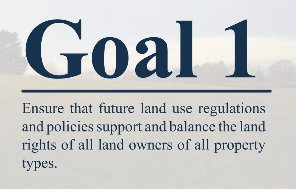
Goal 1: We strongly urge you to edit Goal 1 of the draft comprehensive plan to protect all land rights.
As the Goal is currently written “Ensure that future land use regulations and policies support the development rights of residential and non-residential properties.” It only protects the land rights of those land owners who are interested in developing their land, and thereby forsakes the land rights of neighboring land owners, land owners in conservation, and farmers.
We advocate for editing Goal 1 to protect equally all land rights of all property owners, and suggest the following edits to achieve this.
Goal 1: Ensure that future land use regulations and policies support and balance the land rights of all land owners of all property types.
This edit would still serve the purpose of the current language and serve to provide
protections and support to all land owners not just those looking to develop their land.
Goal 1: Objective 1: Recent developments have shown us that when two dissimilar land uses abut one another that open space buffers need to be required to protect the land rights of all land owners. We are asking the Commission to add an action item 5: Establish in the Subdivision ordinance required buffers in development plans at the junction of dissimilar zones.
Goal 1: Objective 3: Public engagement should also be improved so surrounding land owners rights and the public’s concerns are taken into consideration. We are asking the Commission to add an action item 2: Work to maintain and improve public engagement in the land development process.

Goal 1: Objective 4: This does not define what institutional uses are. Would this include utility level solar? Would someone try to construe it that way? We are asking the Commission to better define “other institutional uses.” Alternatively, remove the phrase and refer only to “medical facilities” in this objective and action item.
Goal 1: Objective 5: Action item 1. This objective is overly broad and does not consider the vast differences across the zones and the land characteristics. We are telling the commission: this should be refined to include only commercial activities associated with agriculture and rural activities or it should be removed.
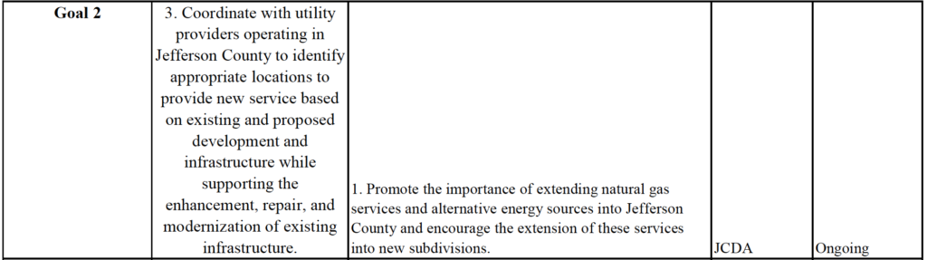
Goal 2: Objective 3: The last water study was done over 12 years ago. Now a large national utility owns the water system that is utilizing groundwater to supply a large portion of the county. We should not add more customers to this utility until an up-to-date study is done. We are asking the Commission to please indicate that groundwater-based utilities should be limited to those serving existing housing developments to preserve groundwater availability for agricultural and animal husbandry uses.
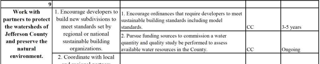
Goal 9: Objective 1: We live in a karst area with sensitive groundwater resources. Therefore, we need to ensure developers take the appropriate precautions and build their stormwater systems according to best practices in karst. We are asking the commissioners to please add an action item to amend the appropriate ordinances to require that developments of all types follow the “Chesapeake Stormwater Network Technical Bulletin No. 1, Stormwater Design Guidelines For Karst Terrain In The Chesapeake Bay Watershed, Version 2.0” and the “West Virginia Stormwater Management and Design Guidance Manual, West Virginia Department of Environmental Protection, Appendix C Stormwater Management Design in Karst Areas” in the design and operation of their stormwater systems.
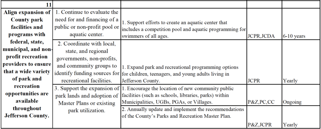
Goal 11: Objective 2: Action item 1. This should include adults of all ages. People of all ages need places to enjoy nature and the outdoors not only the age groups listed. We need to have outdoor spaces that meet the needs of these older adult groups as well.
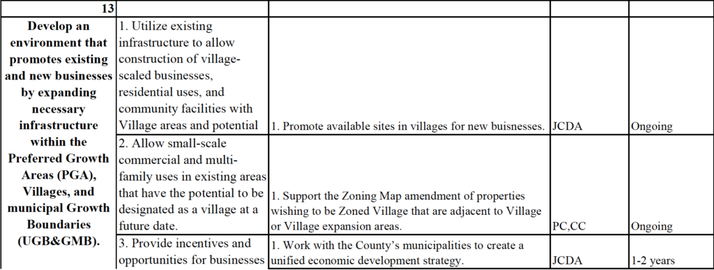
Goal 13: Objective 3: Action item 1. Please add “with engagement of the public.”
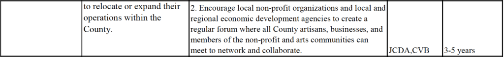
Goal 13: Objective 4: We must consider how this expansion will impact groundwater abundance and quality. We are asking the Commission to change this such that it considers environmental impact of utility expansion including but not limited to groundwater abundance and impact of utility lines due to the karst hydrogeology.
Issues with Proposed Future Land Use Guide (formerly map)
Compare and contrast the previous Land Use Map and the Proposed Future Land Use Guide.
We would like to draw your attention to some specific issues with regard to the Future Land Use Guide. Click the arrow at right of each block to read more.
Previous Future Land Use Map
Currently proposed Future Land Use Map
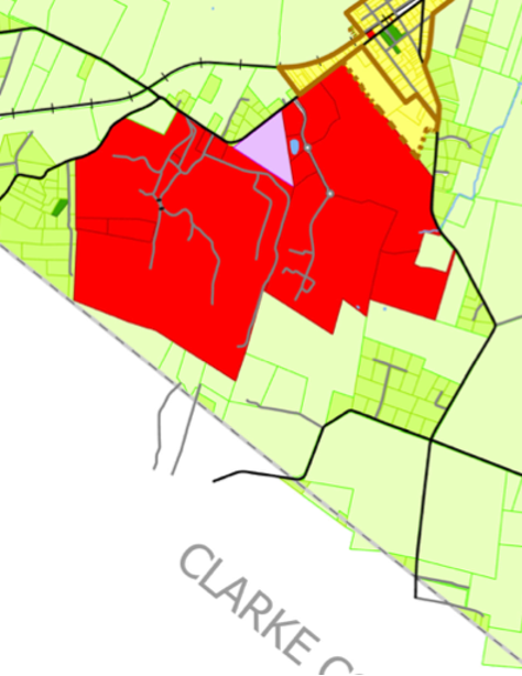
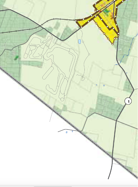
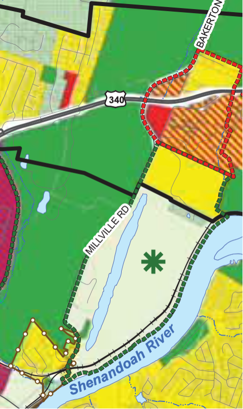
The purple area is designated for industrial or commercial use and the red is designated for general commercial use.
- A large portion of land including and around the summit point raceway has been designated for Commercial use. Most of this land was rezoned for commercial use in 2022.
- A second portion of land in this area has now been designated for industrial use.
- All of this land was designated rural on the previous land use map.Will the infrastructure (water, sewer, roads) be able to support further industrial growth in this area.
- We do not support further industrial growth in the rural areas of the county this may lead to higher risk of air and water pollution.
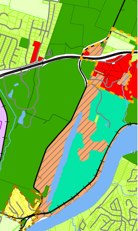
Previous Future Land Use Map
Currently proposed Future Land Use Map
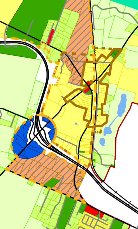
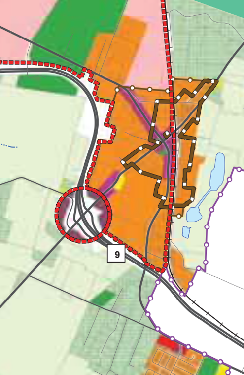
The new salmon and gray hash in the new map is now designated for commercial and or residential uses. This is a concern because of the water utility that serves this area. This utility is a groundwater-based utility. The last groundwater availability study was done over 10 years ago. Before we further increase the number of commercial consumers of this utility, a groundwater study need to be performed to assure adequate groundwater availability.
Previous Future Land Use Map
Current Proposed Future Land Use Map
Previous Future Land Use Map
Currently proposed Future Land Use Map
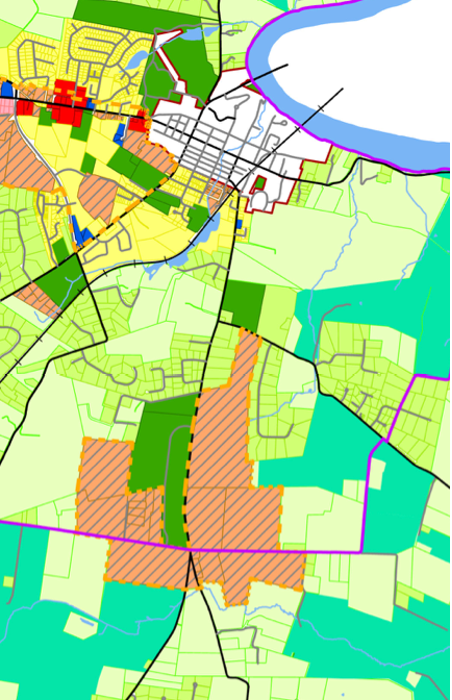
Update: The Planning Commission has removed this from the current Future Land Use Guide for now. We need to watch them to make sure it doesn’t reappear.
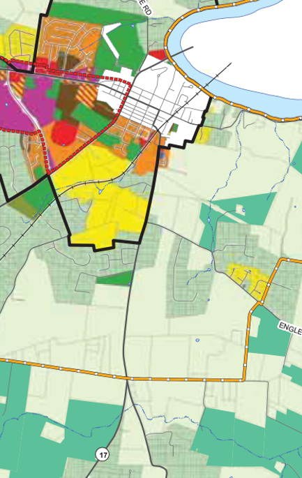
- Area designated for residential or commercial near Shepherdstown. In the last few days the planning commission added a new “residential or commercial” development area on the future land use map encompassing the land currently zoned Rural around the new elementary school. This future land use designation would allow rezoning of this land to accommodate these uses.
- The designated area is much larger than Shepherdstown itself.
- The only purely residential zone in Jefferson County is “Residential Growth” which allows urban level housing (apartments and town houses).
- The only commercial zone in Jefferson County also allows light industrial development.
This amount of development in this area would quickly overwhelm Shepherdstown drawing business out of down town, detracting from tourism, and making agricultural pursuits less and less viable.